Austin T. Blakeslee Natural Area covers approximately 130 acres of protected land. The area features 2.59 miles of walking trails. The Creek Trail, which hugs the banks of Tobyhanna Creek, is 1.14 miles, Highland Trail is .93 miles, and Pine Trail is .52 miles. One highlight of the park is Tobyhanna Falls, a step waterfall. The area has two parking areas, a pavilion, and standing grills.
The site was originally used for farming, and then became a popular recreational park, called Harrison Park. The Flood of 1955 destroyed the park. Remnants of Harrison Park include a stone foundation of the building that housed a roller rink and an artesian well.
The area was purchased through the collaboration of Tunkhannock and Tobyhanna Townships. The project was funded in part by the Pennsylvania Department of Conservation and Natural Resources and the Monroe County Open Space Bond. It was the desire that this area be kept in its natural state, adding only minor improvements to allow the public to enjoy its scenic beauty and to allow fishermen access to the Tobyhanna Creek.

Blanche D. Price Memorial Park covers approximately 24 acres of land and is located directly behind the Tobyhanna Township Government Center. The park has a wide variety of amenities, including two baseball fields, basketball courts, tennis courts, a sand volleyball court, a playground, one main lodge, and a walking path.
The lodge is available for rent from the first week in May through the first weekend of October. You must be a township resident or have a resident who is willing to undersign for you. Reservations are on a first come, first served, and are accepted starting March 1st of each year for that year. Weddings are the only exception to this rule. If you have questions about date availability, please don't hesitate to call us at 570-646-1212. The form for renting the lodge may be Read here.
The site was originally a summer camp for girls, and the boys' camp was located in today's Pinecrest Development. As you walk the path, you can still see the original stone pillars that were the foundations for cottages. The area was purchased by the township in 1975.
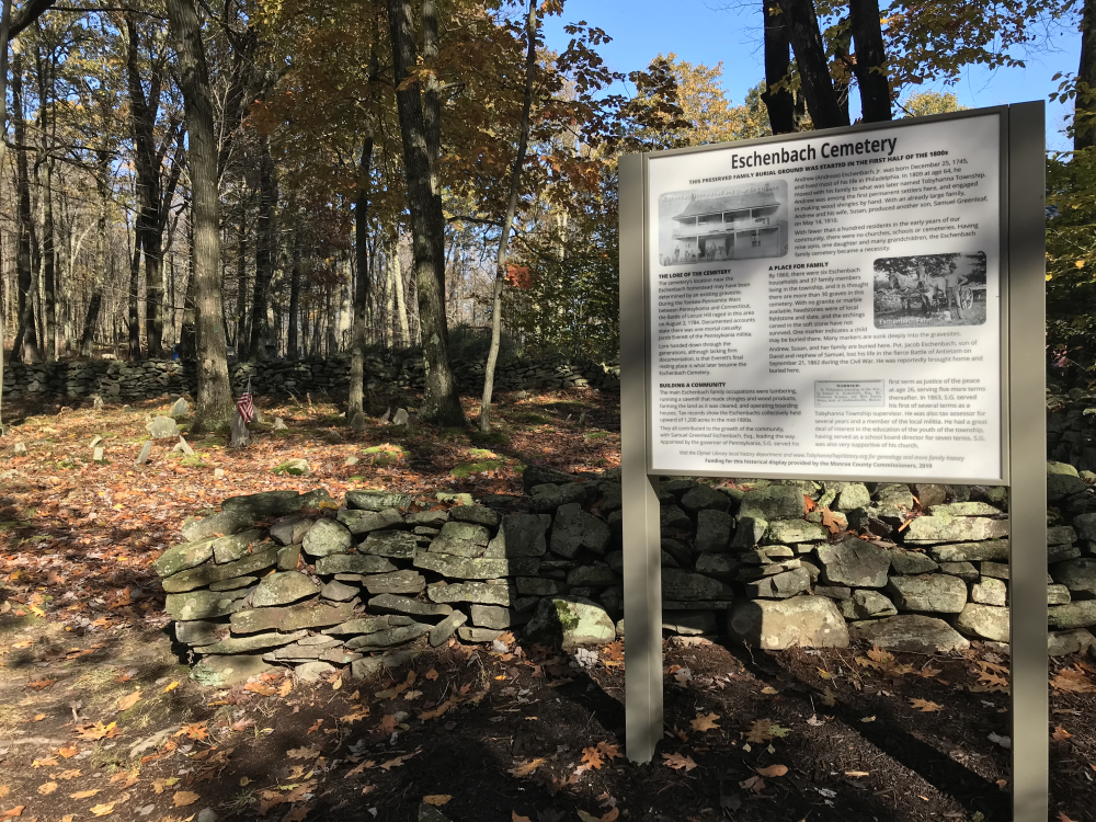
The Eschenbach Cemetery was established between 1810-1830 as a private family cemetery. It is a testament to one of the first permanent families that settled in Tobyhanna Township.
Andrew Eschenbach, Jr., born on December 25, 1745 to Andreas Eschenbach and Johanna Catharina Muntz, was one of the first permanent settlers in Tobyhanna Township. He and his wife, Susan Fink, moved to Tobyhanna Township in 1809. They had 10 children between 1780 and 1810, and had a large enough family that a cemetery became a necessity, as the infrastructure of the township was not sufficiently developed.
It is possible that the location of the Eschenbach Cemetery was determined by an existing gravesite. The Battle of Locust Ridge took place on August 2, 1784 as part of the Yankee-Pennamite Wars between Pennsylvania and Connecticut. Jacob Everett (of Pennsylvania) was the only person to lose his life in the battle. Although lacking firm documentation, lore handed down through generations suggests he is buried in what later became the Eschenbach Cemetery.
The Eschenbach Cemetery headstones are local field stone and slate, which means the etchings have since worn away from natural weathering. While the location of who is buried at what gravesite may forever be a mystery, it is known that the cemetery was the final resting place for Andrew and Susan.
Andreas Eschenbach was born on June 10, 1710 in Naumburg, Saxony in Germany. He arrived in Philadelphia aboard the Friendship on September 23, 1740 as a Moravian missionary sent by Count Nicolaus Zinzendorf (a bishop of the reformed Moravian Church) at the request of Reverend George Whitefield.
Count Zinzendorf held a series of conferences designed to unify different German religions. The third such conference on February 10-12 1742, called the Oley Conference, was located at the DeTurk Farm at current day Historic Ln, Oley, PA 19547. It was here that Zinzendorf ordained Eschenbach into an “undenominations” church.
Soon after the Oley Conference, 16 acres of land were donated to build a school and church. Andreas vehemently advocated for a 42’ by 42’ two-story brick building, similar to the construction of the current Central Moravian Church in Bethlehem, PA, until he’d so harangued his congregation that Count Zinzendorf replaced him.
Andreas married Johanna Catharina Muntz on July 7, 1742. They had three children together: Maria Margaretha (1743-1808), Johanna Elizabeth (1744-1803), and Andreas (Andrew) Jr. (1745-1833). After Johanna died in 1747, he remarried Anna Maria Bossert on June 10, 1747 and withdrew from the Moravian community to become a farmer. They had ten children together: John, Elizabeth, Rachel, Anna, David (d. 1823), Maria (1754-1818), Martha (1757-1839), Christina (1760-1829), Nathaniel, and Salome (1762-1829). Andreas died in 1763 in Oley, PA.
Andrew Eschenbach, Jr. was born on December 25, 1745, to Andrew Eschenbach and Johanna Catharina Muniz, and was the youngest of three children. He grew up in Philadelphia and married Susan Fink, with whom he had ten children. At age 64 in 1809, he and Susan moved to Tobyhanna Township. Of their nine sons, four settled in Tobyhanna Township: David, Nathaniel, Andrew, and Samuel Greenleaf. Their one daughter, Hannah, married Andrew Berry and moved to Wisconsin.
The Eschenbach family’s primary occupations were lumbering, making shingles and wood products with a sawmill, farming as the land was cleared of trees, and running boarding houses. Andrew passed in 1833, and Susan survived him 27 years until her passing in 1860.
David Eschenbach was the fifth child of Andrew Eschenbach, Jr. and Susan Fink. He married Christina Gower and they had five children together: Elias (b. 1835), Jacob (1839-1862), Benjamin (1844-1908), Mariah (b. 1847), and Rachel (b. 1849 or 1850). David died in Butler, PA in 1867.
Jacob (1839 – September 17, 1862) joined the 132nd PA Volunteer Infantry, Company K, as a Private on August 14, 1862. He was killed in action at the Battle of Antietam during the American Civil War.
Benjamin (September 17, 1844 – November 9, 1908) also joined and fought in the Civil War. He mustered in on March 21, 1864 and mustered out on July 14, 1865 as a Private in the PA 67th Regiment Volunteers, Company G. After the war, he married Marietta R. (1837-1916) and they had three children together: Eva (b. 1868), Jesse Warren (b. May 1874), and C.A. (b. 1879). Marietta and Benjamin are both buried in Pocono Lake Cemetery.
Nathaniel Eschenbach was the sixth child of Andrew Eschenbach, Jr. and Susan Fink. Nathaniel married Ellen Scott. They had ten children together: John W., Albert, Sarah, Lydia, James, Mary, George, Eliza, Thomas, and Elizabeth.
Andrew Eschenbach, III, was the eighth child of Andrew Eschenbach, Jr. and Susan Fink. He married Lydia Ann Bond (b. 1811). They had four children: Samuel A. (September 6, 1832 – September 30, 1923), Sarah Ann (b. 1835), Martha (1839-1876), and Henry (September 10, 1843 – January 2, 1925).
Samuel A. Eschenbach is buried at the Blakeslee United Methodist Church cemetery, and his wife, Elizabeth Warner Eschenbach (1835 – March 8, 1897), is buried in Stoddartsville Cemetery.
Samuel Greenleaf Eschenbach was the tenth and final child of Andrew Eschenbach, Jr. and Susan Fink. He married Asenith Lefler, and they had eleven children. He became an influential member of the community; the Governor of Pennsylvania appointed him as Justice of the Peace in 1836, where he served five terms. In 1863 at age 53, he began his first term as a Tobyhanna Township Supervisor. He also served as a member of the local school board, and was heavily involved in his church.
Visit the Historical Association of Tobyhanna Township website to learn about the Marker Advocates program at Eschenbach Cemetery, and many other historical sites in the township.

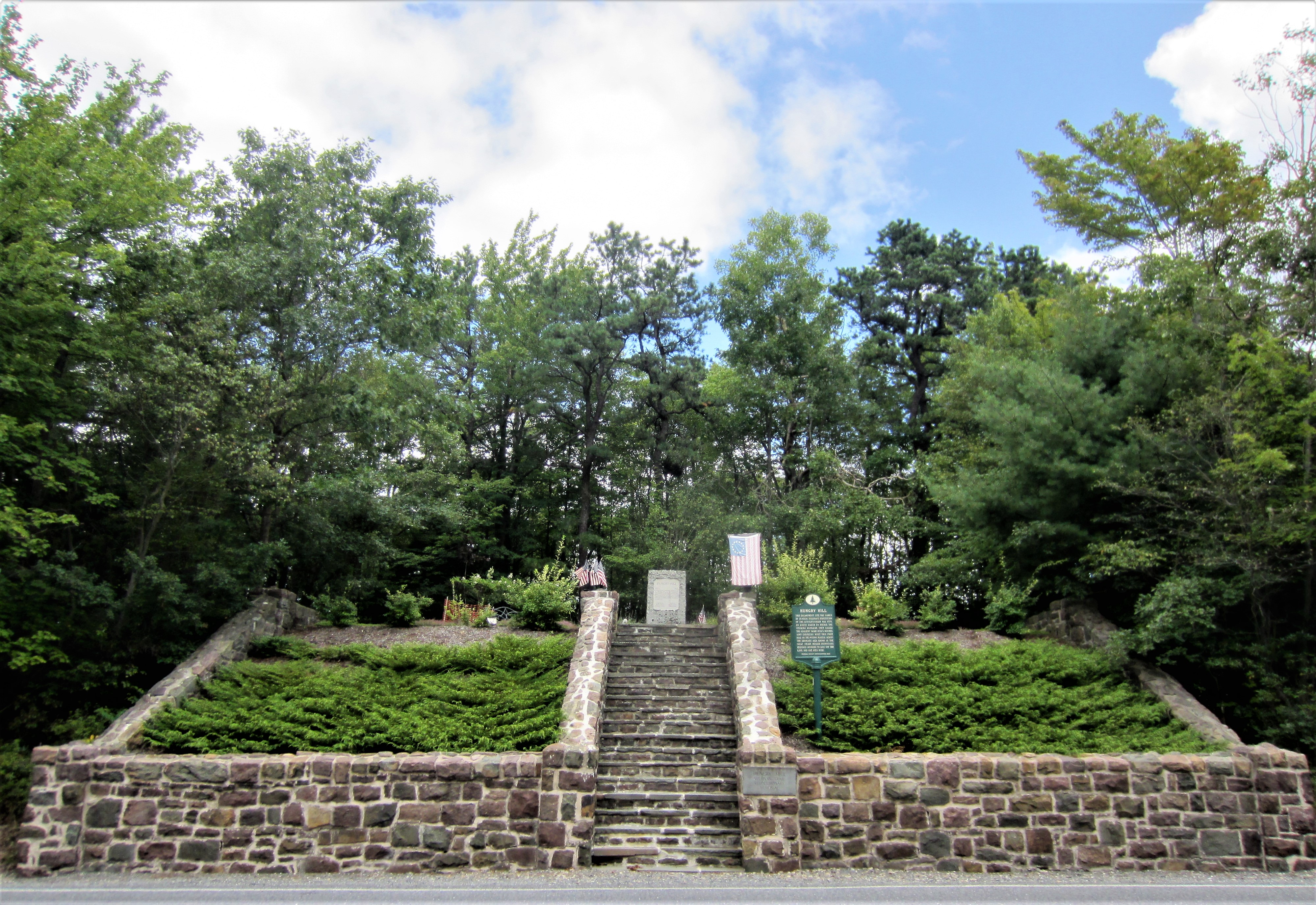
The Hungry Hill Memorial was constructed to honor the Continental Army soldiers who built Sullivan’s Road in 1779. It commemorates the grave of an unknown soldier who perished during the road building in the course of the Revolutionary War. Sullivan’s Road opened the Pocono region, and what eventually became Tobyhanna Township, to settlement and development. Today, the path of the original Sullivan Road within Tobyhanna Township is virtually intact.
The creation of Hungry Hill is one snapshot in the thousands that demonstrate the rich and tumultuous history of the founding of the United States of America and its eventual adoption of the concept of manifest destiny. Take a moment to visit the Hungry Hill Memorial and step back into the history and circumstances that opened Tobyhanna Township to settlers nearly 240 years ago.
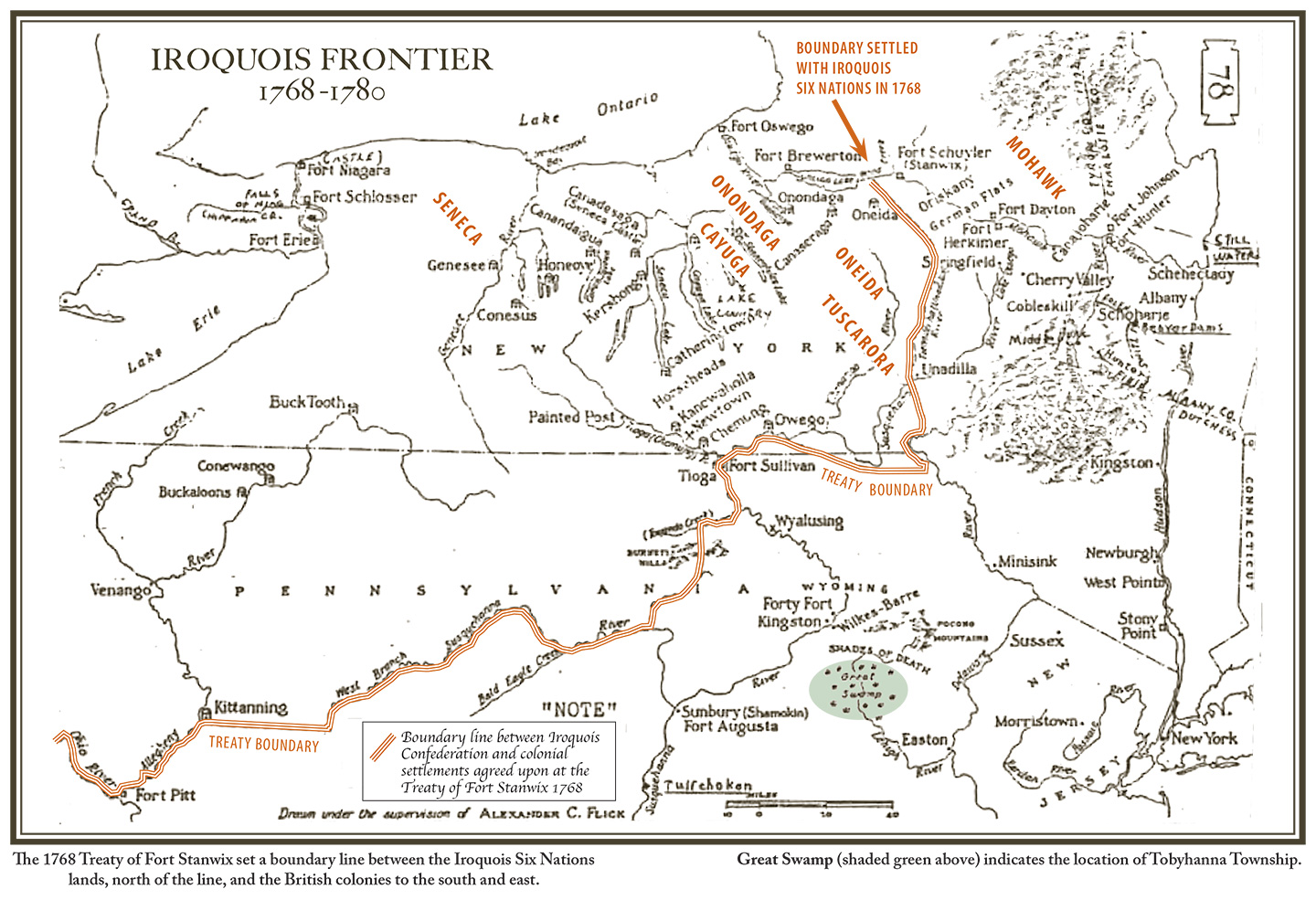
After the United States declared independence from Great Britain in 1776, fighting continued between the Americans, British, and Six Nations of the Iroquois. The allied British and Iroquois forces attacked American troops, militia, and settlers at the Wyoming Massacre on July 3, 1778, and the Cherry Valley Massacre on November 11, 1778. George Washington himself ordered a scorched earth campaign against the Iroquois, and ordered almost one-third of the Continental Army to march north from Easton to New York to commence “the total destruction and devastation of [Iroquois] settlements and the capture of as many prisoners of every age and sex as possible. It will be essential to ruin their crops now in the ground and prevent their planting more” (Washington 716-9).
Map of the Iroquois Frontier - Fig. 2, Courtesy of Rick Bodenschatz.
At this time, no roads existed over the Pocono Mountains to transport an army north into Iroquois territory. Major General Sullivan ordered the building of a road from Tannersville to the Wyoming Valley to allow his army to pass through swamps and heavily forested areas. The road builders were 500 men strong, and were composed of men from the 2nd New York Regiment and the 5th New Jersey Regiment. The two regiments congregated at Learns Tavern (formerly located at 2748 Route 611) and set off May 15-16 to transform a footpath from Learns Tavern to the Wyoming Valley into a road.
A rise in elevation from 883 ft. to over 1,900 ft., densely forested areas, swamps, and the terminal moraine of the Wisconsin Glacier made conditions dismal (Bodenschatz 25). Upon completion of the first nine miles of road on May 23rd, the road builders created an encampment they called Hungry Hill due to the lack of provisions. It was at this encampment where they buried a soldier whose name is lost to history, and where the current memorial stands.
From Hungry Hill, the road builders pressed northwest, where they built a bridge to cross the Tobyhanna Creek. They named the structure Sullivan Bridge. Their encampment was just east of the bridge, along with a smaller encampment at Middle Creek (today’s Wagner Run). Establish next was Locust Hill Camp, and finally Camp Fatigue north of the Lehigh River on June 7th. The road was completed June 14-15.
On Friday, June 18, 1779, Major General Sullivan’s forces of more than 3,500 soldiers, 800 cattle, scores of horses, baggage and supply wagons, pack horses, and canon and gun carriages, broke camp in Easton, PA, and used the newly constructed road to reach the Wyoming Valley on June 23rd.
Sullivan’s three-month campaign eliminated the Iroquois as a British ally and military threat while simultaneously clearing the land of inhabitants to allow for American expansion. On September 28, 1779, Sullivan wrote to Washington stating, “Col. Butler destroyed in the Cayuga Country five principal Towns and a number of scattering Towns, the whole making about 100 in number exceedingly large & well built—He also destroyed 200 Acres of excellent corn with a number of orchards one of which had in it 1500 fruit Trees—another Indian settlement was discovered near new Town (by a party) consisting of 39 new houses which was also destroyed. The number of Towns destroyed by this army amounts to 40 besides scattering houses—the quantity of Corn destroyed at a moderate computation must amount to 160,000 [bushels] with a vast quantity of vegetables of every kind—Every creek & river has been traced and the whole Country explored in search of Indian settlements, & I am persuaded except one… there is not a single Town left in the Country of the five nations” (Sullivan 528-41).
Map of Sullivan’s Expedition Fig. 3, Courtesy of Rick Bodenschatz.
The Six Nations of the Iroquois, ravaged by Small Pox and the annihilation of their farms and settlements, were unable to recover from the scorched earth campaign. Many moved north into Ontario, Canada, where the British eventually granted 675,000 acres of land to form the Grand River Reserve (Johansen and Mann 131).
Visit the Historical Association of Tobyhanna Township website to learn about the Marker Advocates program at Hungry Hill, and many other historical sites in the township.
Keiper Park covers approximately 17 acres of land off of Cross St. The park has a softball field and playground.
Locust Ridge Ball Field is a 5.5-acre lot with a parking lot and baseball field. Locust Ridge Quarry built the parking lot and ball field, and then donated the amenities and land to Tobyhanna Township.
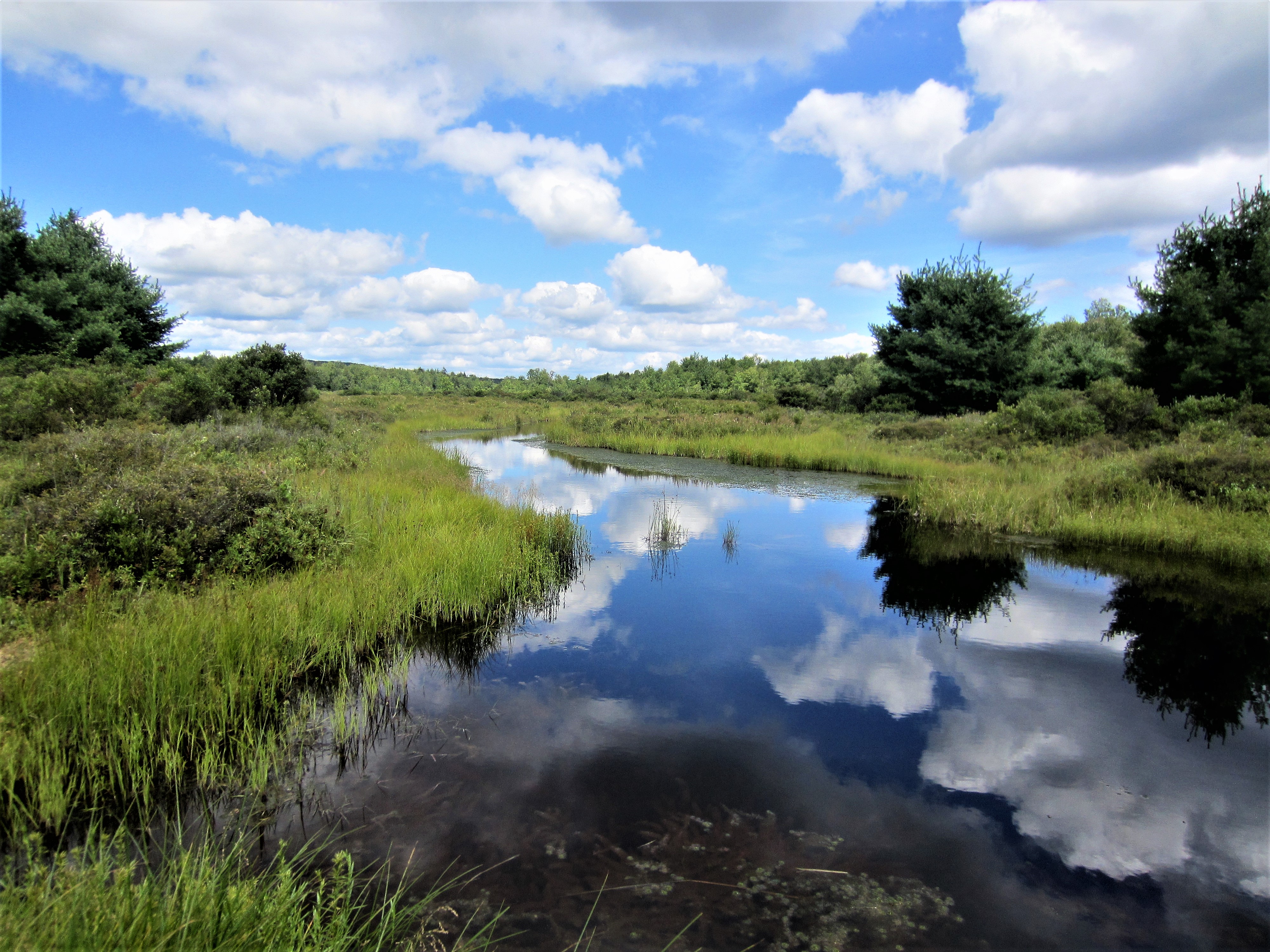
Thomas Darling Preserve is managed by The Nature Conservancy, and covers 2,500 acres. The area is accessible via a 2-mile trail and boardwalk network. The area contains extensive glacial wetlands, and boasts a spring-fed stream, Two-Mile Run.
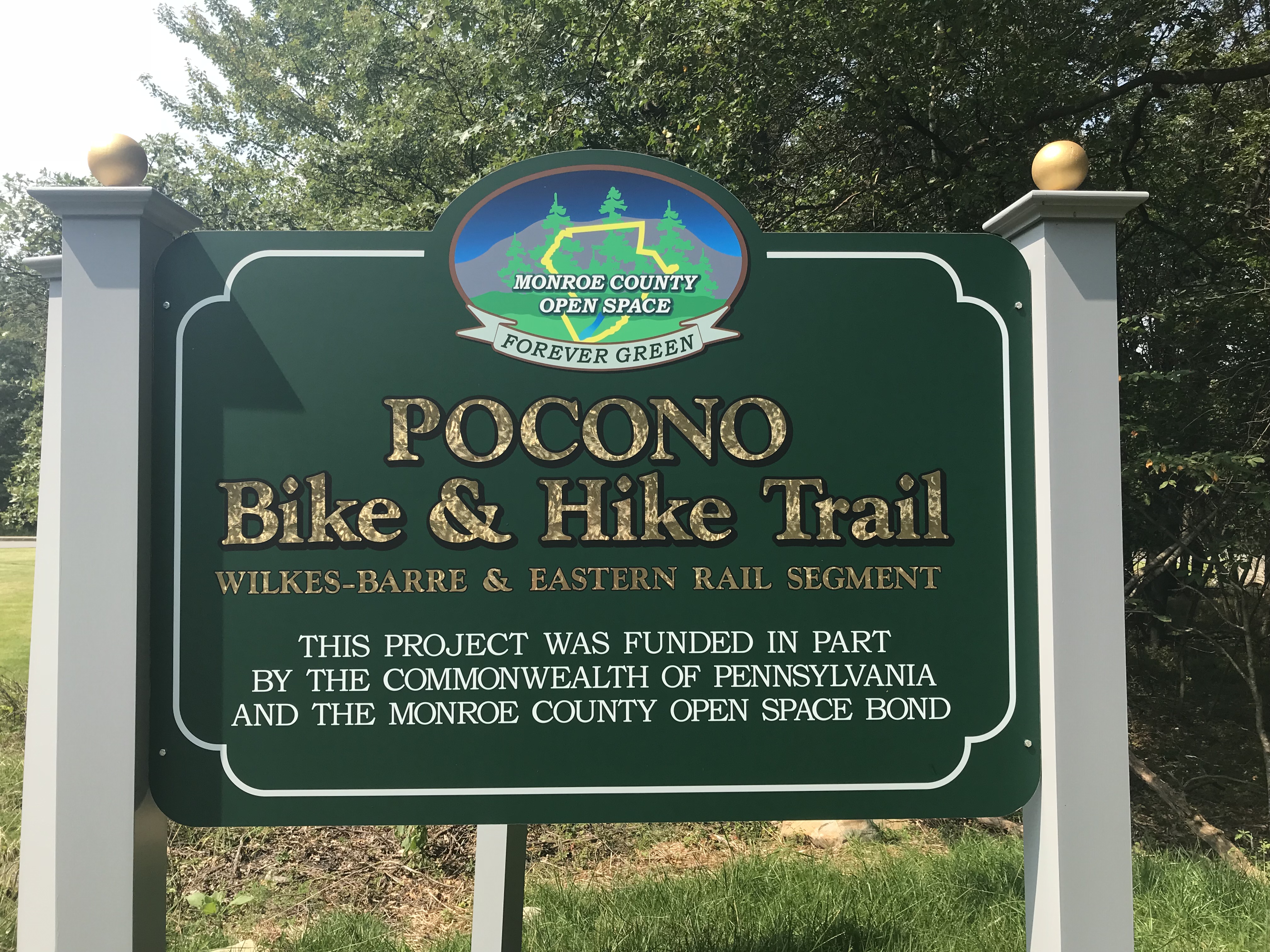
The Pocono Bike and Hike Trail System blends over 28 miles of a variety of eco-tourism and heritage tourism with walking trails, bike trails, over 130 acres of pristine Pocono parks at the Austin T. Blakeslee Natural Area, plus a 1.7-mile walking path on the historic Wilkes-Barre and Eastern Railway Trail.
The trail head is a recently completed project for the township, which is located at 451 Panther Lane. The area features a parking area and informational kiosks donated by the Historical Association of Tobyhanna Township.
